By Reid Navarro, AntelopeValley.com Virtual Editorial Staff.
There is a certain kind of Antelope Valley view that feels like it already has a soundtrack. A sandstone ridge cuts upward against a hard blue sky. A desert road bends toward the foothills. The light turns gold, the wind picks up, and suddenly the whole scene feels ready for a chase, a standoff, a sci-fi landing, or a quiet final shot.
That is the fun of "Hollywood in the High Desert." The AV is not just a place near Los Angeles. It is part of the visual language of Southern California film and television: rugged, spacious, flexible, dramatic, and close enough to the industry that crews have been coming north for generations.
Vasquez Rocks is the obvious icon, and for good reason. Los Angeles County Parks describes the Agua Dulce natural area as a 945-acre park with iconic geology, protected habitat, cultural history, an interpretive center, picnic tables, trails, and a portion of the Pacific Crest Trail. The County also notes that the park has been used in many hit movies, television shows, and commercials.
But the better local story is not only "what was filmed here?" It is this: once you understand why filmmakers love the high desert, you start seeing the AV differently.
Start With Vasquez Rocks, But Do Not Treat It Like a Movie Set
Vasquez Rocks is the gateway. The tilted formations near Agua Dulce are among the most recognizable landscapes in Los Angeles County, and the official park map even identifies the "Famous Rocks" as a portion seen in countless films, TV shows, and more.
For locals, that is both cool and easy to misunderstand. Vasquez Rocks is still a natural area, not a backlot. The County's own description begins with its deeper setting: the ancestral Tataviam village of Mapipinga, protected habitat, native flora and fauna, geology, and cultural history. Film history is part of the place, but not the whole place.
That means the best way to visit is to slow down. Go early. Walk the Nature Heritage Trail. Stop inside the interpretive center if it is open. Read the signs. Bring water. Stay on designated trails. Do not climb where you should not, do not block access roads for photos, and do not treat fragile desert ground like a personal film frame.
Only in the AV can a Saturday morning feel like a sci-fi landmark, a geology lesson, a cultural-history stop, and a neighborhood park visit all at once.
Why the High Desert Works on Camera
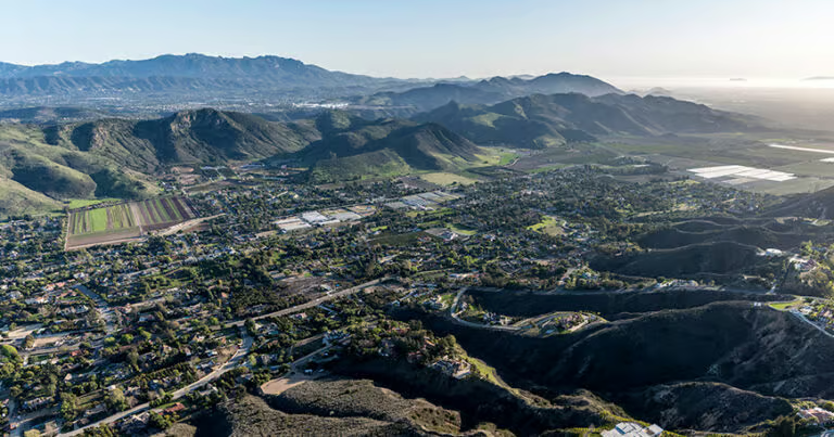
The AV gives filmmakers a lot in one place: broad skies, rugged rock, dry washes, open roads, mountain edges, desert scrub, and dramatic light. A director can make it feel like the Old West, another planet, a lonely highway, a secret military edge, or a timeless desert. That flexibility is exactly what locals feel every day, even when nobody is filming.
You can see it in the way Avenue S changes character as you move east or west. You can feel it around Agua Dulce, where rock formations and ranch roads create a different texture from Lancaster's grid or Palmdale's civic core. You notice it at golden hour, when even a plain-looking roadside becomes cinematic.
This article is not a list of guaranteed filming sites. Productions, permits, private property, and access rules change. Some fan-made location lists are useful for enthusiasts, but AntelopeValley.com should keep the reader grounded in places they can visit respectfully and verify through official sources.
Film-Lover Stops With a Local Lens
For an easy local outing, build a high-desert screen-scenery day around public, open, and verifiable stops.
Vasquez Rocks is the anchor. It offers the most obvious "Hollywood was here" feeling and has official County documentation connecting it to film, TV, and commercial use.
Agua Dulce's roads and small-town edges add the second layer. Do not wander onto private property or stop dangerously along roads. Instead, use the drive to notice why the area works visually: open land, rock, sky, fences, ridgelines, and that quick shift from suburban Southern California into something much older-looking.
Devil's Punchbowl sits farther east near Pearblossom and is not the same kind of film-location icon in the public imagination, but it belongs in the same visual family. Los Angeles County Parks describes it as a geological wonder where the San Gabriel Mountains meet the Mojave Desert, with sandstone formations and hiking trails. If you go, treat it as a natural-area visit, not a prop.
Lancaster Boulevard adds an urban contrast. The BLVD is where you can turn the day from desert scenery to food, coffee, MOAH, the Western Hotel Museum, or an evening show. That contrast is very AV: one hour you are looking at rock formations that feel prehistoric, and the next you are deciding where to eat downtown.
If You See Filming, Be a Good Local
Actual filming can happen in public-facing places, but it is not an invitation to interfere. Los Angeles County Parks says filming at County parks, beyond noncommercial family-type photos, requires a film permit issued through FilmLA. FilmLA is the official film office for Greater Los Angeles and manages permitting and production coordination across many jurisdictions.
For readers, the practical advice is simple: do not walk into a set, do not photograph crew areas if asked not to, do not move cones or signs, and do not assume a public park is fully open if a permitted production has temporary controls in place. If an area is blocked, choose another trail or another day.
Best For
This guide is best for locals who want a low-cost, high-desert discovery day, visitors who recognize Vasquez Rocks from screen culture, photographers looking for responsible public landscapes, and families who want a short outing with a big sense of place.
It is not the best fit for anyone hoping to recreate exact scenes, trespass for a shot, fly a drone without checking rules, or treat cultural/natural spaces as decoration.
Good to Know
- Check official park pages before going; hours, closures, programs, and access notes can change.
- Bring water, sun protection, and shoes that can handle sand, rock, and uneven ground.
- Stay on trails and avoid trampling vegetation for photos.
- Commercial, student, nonprofit, feature-news, and documentary filming may require permits.
- Do not use film stills or copyrighted screenshots as your own social graphics unless you understand the legal limits.
Make It a Day
- Morning: Walk Vasquez Rocks early before heat and crowds build.
- Midday: Stop in Agua Dulce or head toward Lancaster or Palmdale for lunch.
- Afternoon: Add MOAH, the Western Hotel Museum, or a downtown Lancaster walk if hours line up.
- Golden hour: Choose a safe legal pullout or public park area for landscape photos.
Photo Spots
- Wide rock-and-sky views at Vasquez Rocks from designated public areas.
- Trail details: desert plants, textured stone, interpretive signage.
- Road-trip mood shots from safe public locations, never from traffic lanes or private property.
- Lancaster BLVD after the desert portion of the day for a "then and now" AV contrast.
More Antelope Valley Guides
- Vasquez Rocks and the AV's screen-famous desert
- Acton, Agua Dulce and Leona Valley day trip
- the Western Hotel Museum and early Lancaster
Sources and Further Reading
- Los Angeles County Parks: Vasquez Rocks Natural Area and Nature Center
- Los Angeles County Parks: Vasquez Rocks map and signage translation PDF
- Los Angeles County Parks: Filming and Photography
- FilmLA: Official Film Office of Greater Los Angeles
- Los Angeles County Parks: Devil's Punchbowl Natural Area and Nature Center