By Reid Navarro, AntelopeValley.com Virtual Editorial Staff.
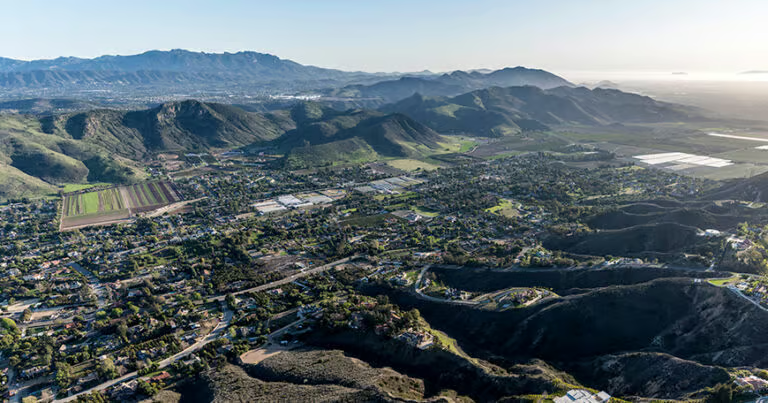
Vasquez Rocks is one of those places where the Antelope Valley-adjacent desert seems to walk into the frame before any actor does. The sandstone slabs tilt out of the earth at cinematic angles. The sky feels oversized. The trails move from open gravel to juniper shade to ridgelines with enough sweep to make even a short walk feel like a scene change.
That is the easy part to say. The harder, more responsible part is this: Vasquez Rocks is not just a backdrop. It is a Los Angeles County natural area in Agua Dulce, a protected habitat, a place of cultural history, and, according to LA County Parks, the ancestral Tataviam village of Mapipinga. It is also a working public park with official trails, rules, sensitive restoration areas, and a county filming process.
So yes, this is a guide for readers searching for Vasquez Rocks film locations. But the best way to enjoy the place is not to treat it like a scavenger hunt for exact camera marks. Treat it like a living landscape that Hollywood borrowed because it already had drama, shape, and story.
What Makes Vasquez Rocks Feel Like a Movie Set
LA County Parks describes Vasquez Rocks Natural Area as a 945-acre park in Agua Dulce with "iconic geology," protected habitat for native plants and animals, cultural history, an interpretive center, picnic tables, educational programs, a group campground, animal ambassadors, and hiking and equestrian trails. The county also notes that a portion of the Pacific Crest Trail passes through the park.
For film fans, the official line that matters most is simple: LA County Parks says the park has been used in many movies, television shows, and commercials. The county's filming page also lists Vasquez Rocks among its popular filming locations and explains that filming in County parks, beyond non-commercial family-style photography, requires a permit handled through FilmLA.
That official framing is useful because it keeps the article grounded. Vasquez Rocks has a very real screen reputation, but production-by-production claims can get messy online. If AntelopeValley.com later publishes a photo caption saying "this exact rock appeared in this exact episode," that should be verified from a production source, studio material, or another strong reference first.
For a local guide, the bigger truth is enough: the geology that made Vasquez Rocks famous on screen is the same geology visitors can see from the public trails. The Famous Rocks area is marked on the LA County park map near parking lot 3. The Nature Heritage Trail connects the interpretive center side of the park with those formations. The Geology Trail gives a short route with interpretive signs. Longer loops add ridgelines, canyon views, and quieter desert texture.
Start With the Park, Not the Screenshot
The first thing to know is that Vasquez Rocks is a county park, not an open film backlot. The official address listed by Los Angeles County is 10700 W. Escondido Canyon Road in Agua Dulce. LA County's service locator lists seasonal public hours and notes that details such as nature center status can change. Before building a day around a particular trail, program, or facility, check the official LA County Parks page and service locator.
That check matters because county pages can sometimes show different facility language at the same time. During research for this draft, the LA County Parks page and official map referred to the Vasquez Rocks Interpretive Center and its amenities, while the LA County service locator noted the nature center as closed while under construction. That is not something to smooth over in a CMS draft. The safe reader-facing language is: the park is open on posted schedules, but visitors should confirm the current interpretive center or nature center status before going.
Once there, the most practical approach is to choose a short route first. Vasquez Rocks can feel close to town, but it is still a natural high-desert environment with limited shade, exposed rock, and changing weather. LA County's map specifically reminds visitors to stay on designated trails, wear weather-appropriate clothing and shoes, bring sunscreen and a hat, carry plenty of water, and follow Leave No Trace principles.
The film-location magic is near the front of the visit. The official map labels "The Famous Rocks" as one of the most iconic portions of the park and places it adjacent to parking lot 3. From there, visitors can keep the day easy with nearby trails or extend into a more strenuous loop.
A Simple First-Visit Route
For most locals bringing out-of-town guests, a good first visit starts with the official map, not a social-media pin. Park in a designated lot, orient yourself at the interpretive center area if open, then walk toward the Famous Rocks using the Nature Heritage Trail or other marked paths.
The Nature Heritage Trail is listed by LA County as the main route between the interpretive center and the Famous Rocks. The map describes it as featuring interpretive signs on native plants, animals, and cultural history. That makes it a better first choice than wandering across bare ground in search of a photo angle.
For a short geology-focused walk, the Geology Trail is listed as a brief scenic trail with interpretive signs about the park's geological history. The map says it can be used as an out-and-back trail or as a connection to the Pacific Crest Trail, Homestead Trail, or parking lot 2. This is the kind of trail that works well for visitors who want the landscape without turning the day into a long hike.
For families, mixed-age groups, or anyone who wants a flatter option, the Juniper Meadow Walking Loop is described on the county map as a relatively flat, non-rocky dirt pathway near the famous formations. LA County notes it may be usable by small children, most strollers, wagons, and some mobility devices. Because surface conditions can change, accessibility-sensitive visitors should still verify current conditions before relying on it.
For hikers who want more distance, the Homestead Trail, Apwinga Loop Trail, Tokupar Ridgetop Trail, Bobcat Trail, and the park's Pacific Crest Trail segment offer more ways to understand the place beyond the front formations. Those routes should be chosen by ability, heat, daylight, and the official map's difficulty ratings.
How to Enjoy the Film History Without Damaging the Place
The most tempting mistake at Vasquez Rocks is to see a familiar angle and step off trail for a cleaner shot. That is exactly what visitors should not do.
LA County's official map tells visitors to stay on designated trails and notes that walking off-trail increases the risk of injury or getting lost. The same map identifies restricted habitat restoration areas where entry is prohibited. The park page also emphasizes protected habitat. A photo is not worth compacting soil, trampling vegetation, disturbing wildlife, or creating a social trail that other visitors follow.
Instead, use the tools filmmakers use: distance, timing, lens choice, and patience. A phone camera from a marked path can do more than people think, especially early or late in the day. A zoom lens can visually stack the rocks without requiring anyone to stand in a fragile area. A photo with people on an official trail often reads more honestly than a staged shot in the middle of habitat.
If you are a casual visitor taking family or travel photos, keep it small, personal, and respectful. If you are planning a student film, commercial shoot, documentary, publication shoot, fashion session, or anything beyond ordinary personal photography, start with the LA County filming and photography rules and FilmLA. The county states that filming at County parks, other than non-commercial family-style photography, requires a film permit through FilmLA.
That is not red tape for its own sake. Vasquez Rocks is popular, exposed, and ecologically sensitive. Film permits help parks manage vehicles, equipment, crew movement, timing, closures, and public use.
The Cultural Context Belongs in the Story
Vasquez Rocks is often discussed through geology and film, but the county's own description begins with place and cultural history. LA County Parks identifies the area as the ancestral Tataviam village of Mapipinga. The official map also marks a Tataviam food processing site and describes it as a historic cultural food processing site used by Tataviam ancestors hundreds of years ago.
For a local publication, that matters. The film story should not erase the older and deeper story of the landscape. Avoid writing about the rocks as if they were empty until Hollywood arrived. Avoid costumes, props, or captions that treat Native history as scenery. Keep cultural claims sourced to official park, tribal, museum, or academic materials. If AntelopeValley.com later expands this into a deeper heritage article, it should involve source-led cultural review.
The same care applies to the name Vasquez. The park is associated with Tiburcio Vasquez in popular history, but the more useful reader-facing approach here is to point people to the park's interpretive materials rather than over-telling unsourced outlaw lore. The Homestead Trail is described by LA County as including interpretive signage on post-European-contact history from the Spanish era to the 1960s, which gives visitors a grounded way to learn on site.
Best Times to Visit for Photos
For photography, the most forgiving light is usually early or late. Midday sun can flatten the formations and make the pale rock harsh. Morning can bring cooler walking temperatures, calmer parking, and cleaner shadows. Late afternoon can add warmth to the sandstone, though visitors must keep an eye on posted closing times, daylight, and the drive out.
Wind and heat matter. The park has limited shade, and LA County recommends sunscreen, hats, weather-appropriate clothing, and more water than visitors think they need. Their map gives a practical minimum: at least 1 liter of water for every two hours. That is a planning baseline, not a challenge to carry less.
Weekends can be busier, especially during mild weather, spring blooms, or after a film-related location goes viral again. If you want a quieter experience, try a weekday morning when schedules allow. If you go during a busy period, build in patience. This is a shared public space, not a private photo studio.
What Not to Do at Vasquez Rocks
Do not climb into restricted habitat restoration areas. Do not walk off trail to recreate a scene. Do not block trails with tripods, props, or groups. Do not assume a filming setup is allowed because it is small. Do not bring open flames; LA County's map identifies the park as a high fire danger area and says no open flames or incendiary devices. Do not leave trash, chalk marks, confetti, fake blood, costume debris, or anything else behind.
Also avoid giving unsafe or hyper-specific access tips in captions. "Walk toward the Famous Rocks from the designated parking area using marked trails" is useful. "Scramble behind this boulder and duck through this gap" is not.
The most local thing a visitor can do is act like the place has to be here next season, next decade, and for the next group of kids discovering that their own backyard looks like another planet.
A Half-Day Plan for Locals and Guests
Start by checking the official LA County Parks page, service locator, weather, and map. If the interpretive center is open, begin there. If it is closed or under construction, use the official map and posted signs.
Walk the Nature Heritage Trail toward the Famous Rocks. Pause for the classic wide view from legal, durable surfaces. If your group wants a short educational add-on, take the Geology Trail. If your group wants a slightly fuller park experience, add the Juniper Meadow Walking Loop or another route that matches the group's ability and the day's weather.
Keep lunch simple. Use designated picnic areas when available, or plan to eat before or after in Agua Dulce, Acton, Santa Clarita, Lancaster, or Palmdale. Do not make a meal out on the trail where food is not appropriate or where trash can spread.
If you are turning the outing into a wider high-desert day, pair Vasquez Rocks with an Agua Dulce stop, a scenic drive through nearby canyon roads, or a separate Antelope Valley article route. Keep the driving plan conservative. Rural roads can be narrow, fast, and distracting when the landscape is good.
FAQ
Is Vasquez Rocks really a film location? Yes. LA County Parks says Vasquez Rocks has been used in many movies, television shows, and commercials, and the county lists it among popular film locations. Specific title-by-title claims should be verified before publication captions or promotional copy.
Can visitors take photos there? Personal, non-commercial photos are generally different from permitted filming or commercial photography, but rules can change and larger shoots require review. LA County says filming at County parks, other than non-commercial family-style photography, requires a FilmLA permit.
Where are the Famous Rocks? LA County's official map labels the Famous Rocks near parking lot 3. Use the posted map, designated lots, and marked trails rather than social-media shortcuts.
Is the interpretive center open? Check before going. During research for this draft, LA County materials referenced interpretive center amenities, while the LA County service locator noted the nature center was closed while under construction.
Good to Know
- Check the official LA County Parks page and service locator before visiting because hours, facility status, programs, and access notes can change.
- Bring water, sun protection, sturdy shoes, and a charged phone; shade is limited and the park is a natural area.
- Stay on designated trails, respect restricted habitat restoration areas, yield to equestrians, and avoid open flames.
- Treat specific film-title claims as fact-check items before using them in captions, maps, or social posts.
Make It a Day
- Start with the Famous Rocks and a short marked trail, then add the Geology Trail or Juniper Meadow Walking Loop if conditions and ability allow.
- Pair the visit with a low-key meal stop in Agua Dulce, Acton, Santa Clarita, Lancaster, or Palmdale, checking current hours before you go.
- Build a broader "Hollywood in the High Desert" day with nearby officially accessible locations only; do not enter private property or restricted land for photos.
More Antelope Valley Guides
- Hollywood Beyond Vasquez Rocks
- Acton, Agua Dulce and Leona Valley day trip
- A responsible wildflower day in Lancaster